Coosa Riverkeeper has been conducting additional bacteriological sampling along the entirety of Big Canoe Creek for the past few weeks to investigate the large number of high E.coli alerts we issued last summer.
We wanted to share with you our findings and our next steps below:
The 1st week of sampling was on the upper section of Big Canoe Creek, from the headwaters around Cedar Mountain Road to around a little below Murphrees Valley Bridge. The proposed sample locations were public access sites found on Google Maps, and a couple sites accessible through members of Coosa Riverkeeper. Once out in the field, Jake and Chad had to cut a few sites due to a bridge being out, and not actually being able to access one or two others originally thought to be public access. The samples from this section were all green (or low E.coli) alerts.
Week 2 of sampling took place on the middle section of Big Canoe Creek. Washington Valley Rd. Bridge to Double Bridge Rd. Bridge. These sample locations were selected the same way, prioritizing public access and one private site with the help of a donor. One of these sample locations is a Swim Guide site (the 5th Ave. bridge in Ashville). The samples from this section were all green (or low E.coli) alerts.
Week 3 of sampling took place on Big Canoe Creek, Little Canoe Creek, and a few other tributaries from Springville to Steele. We delayed sampling the lowest section of Big Canoe Creek this week because we needed to organize getting a boat to sample the lowest section due to a lack of foot/truck access. These sample locations were selected prioritizing the local wastewater treatment plant and lagoon outfalls. No samples were taken directly at outfalls as access directly to them isn’t possible, but the samples were taken downstream of outfalls. A few samples were also just at public access sites, not strictly outfalls. The samples from this section were all green (or low E.coli) alerts.

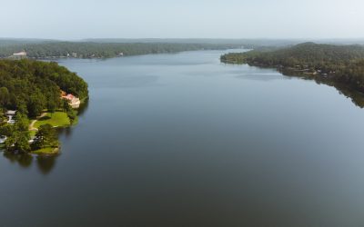
Week 4 of sampling, with the help of an advisory council member, occurred on the lowest stretch of Big Canoe Creek. The highest up sample from the day took place just downstream of where Little Canoe Creek drains into Big Canoe. A handful of samples were taken downstream towards the Hwy 411 Bridge. A few other samples were taken as well, such as the embayment where Rook Creek and Dry Creek drain (near Hwy 411 Bridge), as well as the Palmetto Creek Slough (Permeter Creek on the map). The samples from this section were all green (or low E.coli) alerts.
There are a couple of potential factors for why our test results are vastly different from our summer results. First, it could be that during this time of year, many folks are not applying fertilizer to their pastures. Second, it could be that cattle who may find respite in the creek during the summer heat are not entering the creek. Our Program team has been monitoring Discharge Monitoring Reports from the permitted polluters in the vicinity of Big Canoe and Little Canoe Creek. We have collected samples from some of these facilities over the past few months and did notice some elevated water quality issues. Our next immediate step in investigating this issue will begin a multi-day paddling effort to determine where cattle may be entering the creek. We will note those locations on an internal map and will follow up with sampling some of those locations in the warmer months. We intend to continue sampling the creek into the Spring and Summer months to determine any additional non-point source pollution and seasonality issues that could be impacting water quality.
In short, the issues on Big Canoe Creek are multi-faceted. We believe there are multiple non-point source pollution issues that are exacerbating the bacteria issues we’ve detected. Help us continue this investigation by supporting our work and please report any pollution to us!